Swoop
Field data capture & enrichment
Capture and enrich business data
from any main street.
Photograph shopfronts or import a spreadsheet. Swoop enriches every record with ABN, ANZSIC, address verification, land data, zoning, and census demographics — automatically.
Built for Australian council economic development teams and consultants.
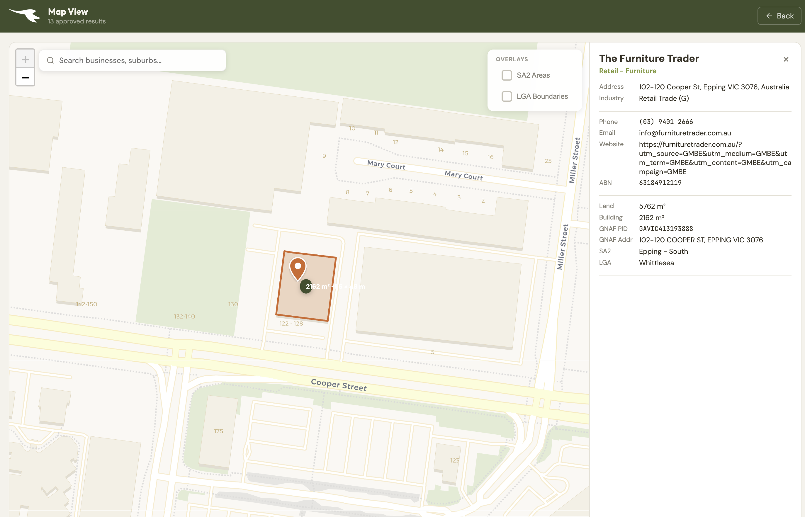
Map view — land parcel · planning zone · GNAF address · SA2 / LGA context
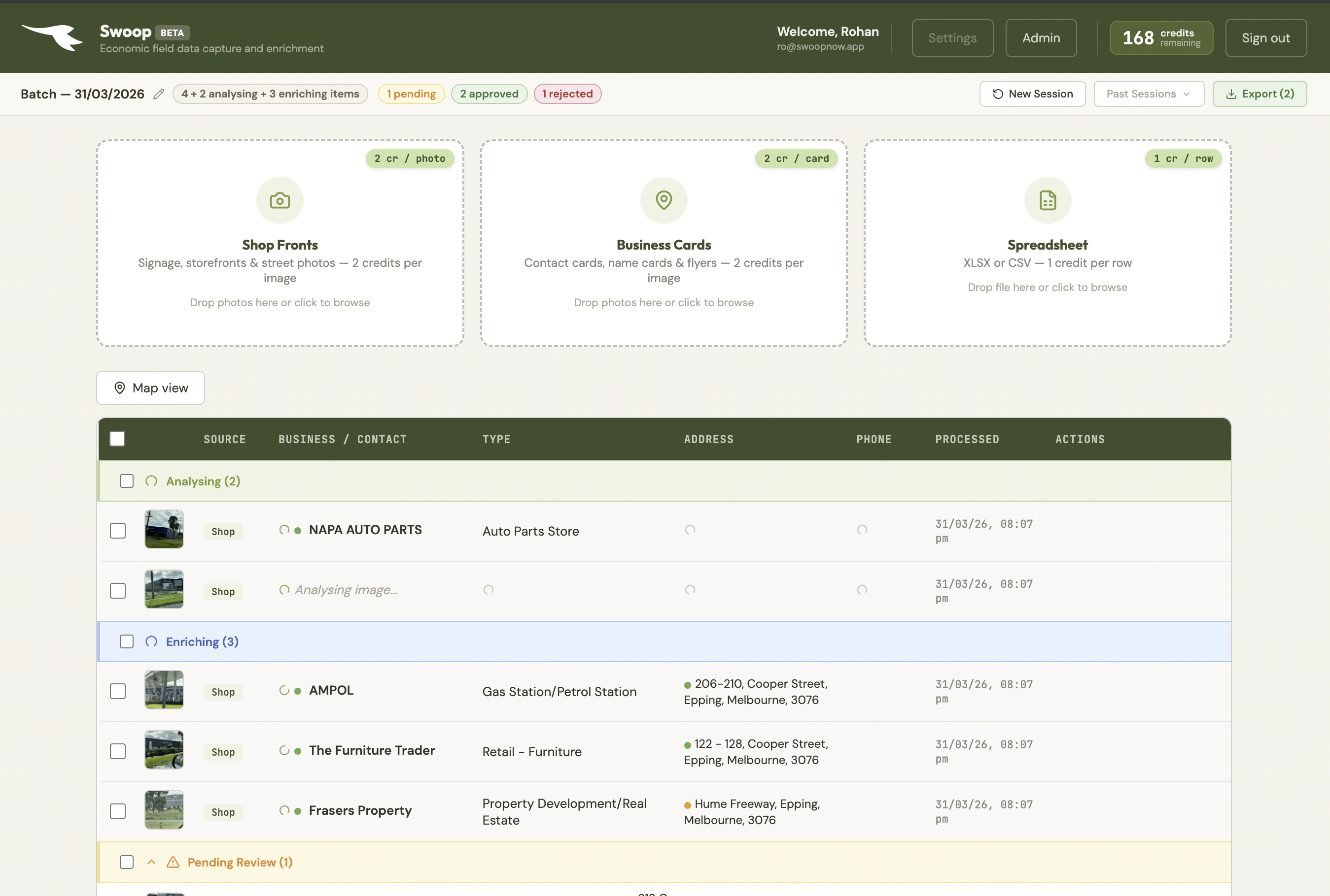
From photo to enriched data, in seconds.
Walk any main street. Photograph every shopfront. By the time you're back at the desk, every business is identified, geocoded, ABN-matched, zoned, and industry-classified.
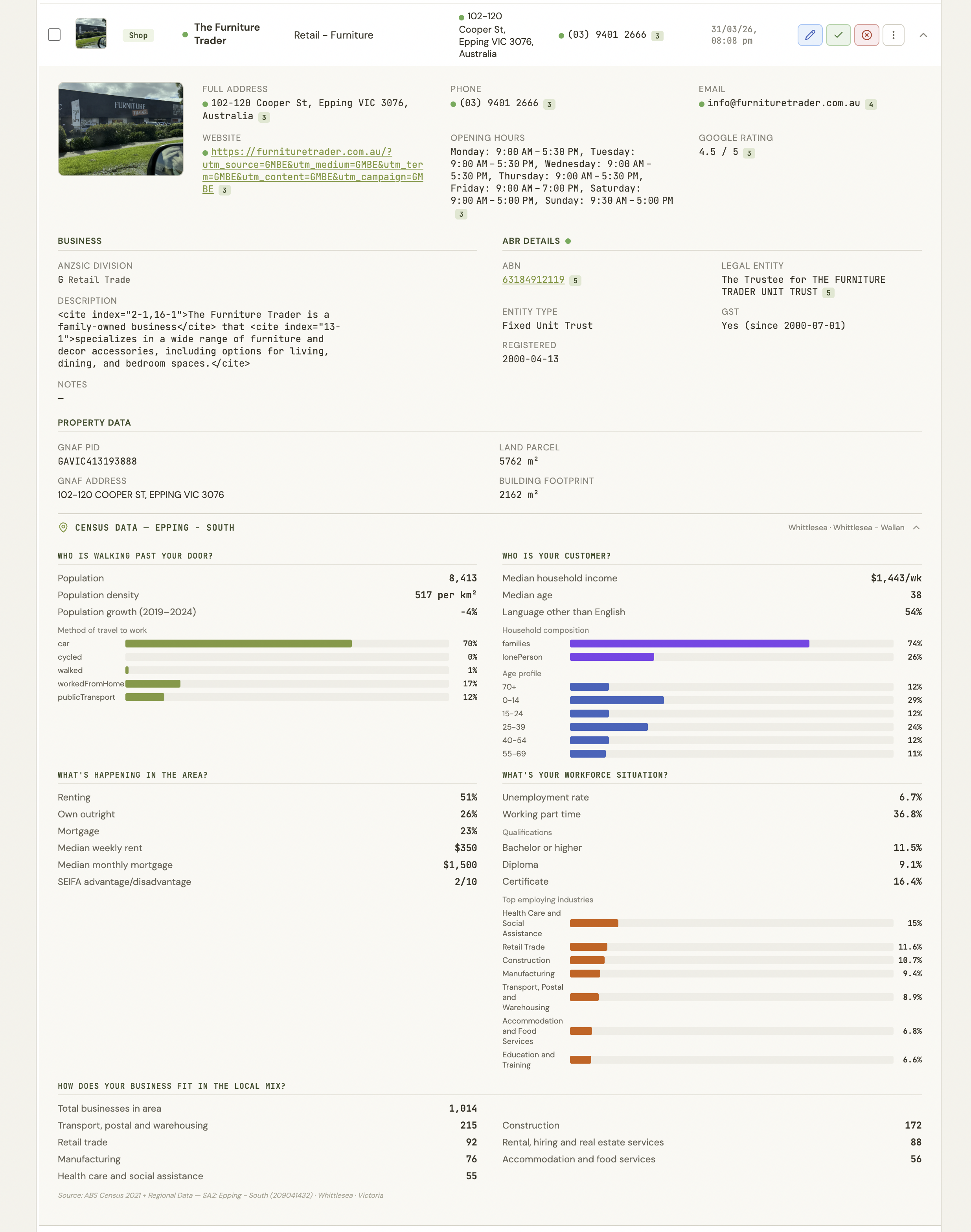
Seven data layers from a single photo.
Every record is automatically cross-referenced against Australian government databases. One photo or spreadsheet row becomes a deeply structured business record.
Built for economic development practice.
The data broader sources can't give you — captured in the field, structured automatically, ready for strategy work.
Replace LGA-level aggregates with real business composition data for any main street or township. Know exactly what's on the ground.
Give investors precise street-level snapshots — active businesses, industry mix, land use zoning, and demographic context.
Capture field evidence of business activity tied to specific locations. Structured, exportable data for accountability and audit trails.
From enrichment to ongoing intelligence.
Swoop is building toward a full business composition intelligence layer. These features are in active development.
Collaborate across teams and organisations with shared business registers. One source of truth for your LGA or region.
Define precincts and activity centres. Visualise business composition, tenancy mix, and land use at the precinct level.
Track changes over time. See what opened, closed, or changed category between field captures — with longitudinal reporting.
Identify and map vacant shopfronts across your main streets. Monitor vacancy rates over time with automated detection.
Swoop doesn't write strategies. It captures and enriches the structured field data that makes analysis more granular, investment prospectuses more compelling, and recommendations more grounded — for council officers and consultants alike.
Australian servers with ABR, GNAF, ABS Census, and state planning scheme integration. Designed from the ground up for Australian economic development practice.
What you get, state by state.
National datasets like GNAF, Census, and ABR work everywhere. State-specific integrations are expanding.
| Feature | NSW | VIC | QLD | SA | WA | TAS / NT / ACT |
|---|---|---|---|---|---|---|
Cadastral parcels Property lot boundaries from state ArcGIS services | ✓ | ✓ | ✓ | ✓ | ✓ | — |
Address resolution Street address from state property APIs | ✓ | ✓ | — | — | — | — |
Zoning overlays Planning zone code and description | ✓ | ✓ | — | ✓ | ✓ | — |
Property metadata Complex name, building name, property type | ✓ | ✓ | — | — | — | — |
Planning overlays Detailed planning scheme overlays | ✓ | ✓ | — | — | — | — |
GNAF addresses Geocoded National Address File identifiers | ✓ | ✓ | ✓ | ✓ | ✓ | ✓ |
ABS Census SA2-level demographics, income, workforce, SEIFA | ✓ | ✓ | ✓ | ✓ | ✓ | ✓ |
ABR lookup ABN, entity name, GST status, trading names | ✓ | ✓ | ✓ | ✓ | ✓ | ✓ |
Cadastral APIs cover NSW, VIC, QLD, SA & WA — ~95% of Australian businesses. Nominatim reverse-geocode is the fallback for address resolution in states without a dedicated API.
Simple, transparent pricing
Monthly subscriptions — cancel any time, no lock-in. Unused credits roll over.
Try it out — no credit card required
For individual officers and small audits
For consultants and municipality-wide audits
For large-scale field campaigns